During the summer in Cyprus, we are looking for ways to cool down. Some will choose to swim in the sea, in the swimming pool, while others will choose air-conditioned rooms. However, we prefer the coolness of the forest, the mountain air, and the chilly breeze from a cold stream that leads us to a waterfall! Yes, waterfall! Perhaps some of you didn't know that Cyprus also has waterfalls... others may even know about a few… but there are actually many more. I personally know of at least eleven, but there are surely even more.
However, not all of them flow continuously throughout the year, as it depends on the terrain through which the rivers pass and the amount of rainfall during winter. In Cyprus, there are also waterfalls that exceptionally show up only once every few years. They say that when they appear, it's a good sign - and these are not tiny waterfalls at all! They might astonish anyone! (Here I am mainly referring to the Paradise waterfall in Trozena).
Introduction
In today's post, I will show you 3 beautiful, well-known, highly visited by tourists and easily accessible waterfalls. Each of them has its own amazing charm and I believe that while in Cyprus, you must go for a walk, at least to one of them.
I wrote “for a walk” on purpose because just driving up to the waterfall and admiring it is just “the cherry on top of the cake”. There is nothing more wonderful than walking through a shaded, cool forest wrapped by the symphony of a strong stream, swaying trees, birds singing, and breathing in clean, crisp air. Aromas of the pine trees and wild herbs. And upon reaching the waterfall, you'll be greeted by an even cooling blast of air and a refreshing mist of cool splashing water.
It is known that depending on the season, the water in the waterfalls will flow with more or less force. So after a dry and hot summer, the waterfall may appear smaller or less beautiful, while it will be the most beautiful and impressive at the beginning of spring.
As I mentioned, some waterfalls dry up completely, and others appear only every few years. However, these three waterfalls, about which I will write here, "live" all year round.
Kaledonia Waterfall (Καλιδωνίων Kαταρράκτη)
- the most famous waterfall in Cyprus and the most visited by tourists.
 |
| Kaledonia Waterfall (May 2015) |
Where is the Kaledonia Waterfall located?
It is situated north of the most famous Cypriot mountain village in Troodos - Pano Platres, at an altitude of 1330 meters above sea level, in the Troodos Forest National Park, which is a part of the Natura 2000 program.
It was formed on the Krios (Kryos) Potamos (κρυός ποταμός) river, also known as the Cold River.
The Kaledonia Waterfall is 13 meters high and the waterfalls on the hard gabbro rocks (deep sea rock) create a small pond at its base. Despite the icy water, there will be always people willing to take a dip in its waters.
In some places, it is said that it is the highest waterfall in Cyprus, but that honor belongs to the taller Millomeri Waterfall.
Its name - the Kaledonia Waterfall - most likely comes from Scottish travelers who, enchanted by its beauty, nostalgically noticed that the waterfall, together with all the surrounding nature, resembled their homeland in Scotland. Therefore, they named it Kaledonia (Caledonia) - as the ancient Latin name of Scotland sounded.
There is another explanation for the name of this waterfall and its origin is connected with swallows (chelidon urbica) living nearby in the treetops.
I also checked the direct translation from Greek and the translator suggests that depending on where the accent placement, Καληδόνια (Kalidonia) can mean "good night," while Καληδονία (Kalidonia) can mean "good evening." This explanation is also interesting, but probably much less romantic.
Vegetation
Due to the fact that the Kyros Potamos River never runs dry, a dense forest (Riparian Forest) with lush vegetation grows around it.
Here you will mainly see:
- calabrian pines (Pinus Brutia) - found at lower altitudes,
- and black pines (Pinus Nigra ssp. pallasiana) - found at lower altitudes.
Many of them are centuries old!
In addition, it grows here:
- the endemic Golden oak (Quercus alnifolia), black poplar (Populus nigra), oriental alder (Alnus orientalis), oriental plane tree (Platanus orientalis), juniper (Juniperus foetidissima) and cretan barberry (Berberis cretica),
- strawberry tree (Arbutus andrachne) - not to be confused with the strawberries we know 😉 apart from the similar appearance of the fruit, they have nothing in common;
- ubiquitous ivy (Hedera Helix) and moss,
- endemic plants, such as Troodos sage (Salvia willeana), Urse mint (Mentha longifolia subsp. Cyprica), Aphrodite’s spurge (Euphorbia veneris), Thorny gorse (Genista fasselata subsp. Crudelis), Purple Rockcress (Arabis purpurea), Troodos wild-rose (Rosa chionistrae)
- and various other interesting plants, shrubs, and trees - rockrose (Cistus), white willow (Salix alba),
oleander (Nerium oleander), giant reed (Arundo donax), bay laurel (Laurus nobilis), bramble (Rubus sanctus), myrtle (Myrtus communis), white beam (Sorbus aria ssp. cretica), cotoneaster (Cotoneaster racemiflorus var. nummularia) etc.
In the water stream, you can spot a crab or a trout (but fishing is not allowed!).
How to get to Kaledonia Waterfall?
There are several possible ways to reach Kalidonia Waterfall.
1. Trekking along the Kaledonia Trail (upstream, along the river) - which I highly recommend, because during this walk you can observe the wonderful landscape and fully appreciate this natural wonder.
You can park your car right at the very beginning of the trail, next to a restaurant with a trout farm. The beginning of the trail is about 300 meters from the "Psilo Dendro - Trout Farm & Restaurant" sign (1200 meters above sea level). After 1.5km you will reach the Kaledonia Waterfall and then you can continue trekking up the trail towards Troodos or return to Pano Platres.
The trail to the waterfall leads through a wonderful dense forest, rich in endemic vegetation. Along the educational path, you will see signs describing trees, shrubs, and plants. The trail has a 2nd or 3rd degree of difficulty (out of 3) because the road crosses the river many times and requires walking over slippery stones and leads uphill. The path itself can also be slippery. In recent years, several additional bridges have been built, so now the passage along this trail is a little easier. We meet families with children on it many times, so it can't be that difficult.
The road to the waterfall takes about 40 minutes (with a slight uphill incline), and the descent takes about 30 minutes.
2. Trekking the Kalidonia Trail (downhill) - the starting point of the trail (approximately 1600 meters above sea level) is located about 2km from the main square of Troodos, following the Old Road, which begins around 350 meters from the square, at an elevation of 1725 meters above sea level. After descending the old road for about 1.7km, you will reach an information board with a map of the Kalidonia Trail. From there, it's another 1.5km to reach the waterfall.
Descending along the Kryos Potamos river is probably the easiest way, but the route is much longer, and you will still need to find a way back afterward. 😏 I would suggest having someone wait for you with a car at the bottom in Pano Platres or taking a bus to Troodos and returning from Platres. Otherwise, you will have to climb uphill for the return journey. 😊
Descending the entire trail covers a distance of 3km and takes about 1.5 (up to 2 hours).
3. The shortest and easiest option for those who do not enjoy walking is to park near Kaledonia Waterfall (to the west of it) and take a short forest path.
Coordinates of Kaledonia Waterfall: 34° 54 10 N 32° 52 14 E
Otherwise spelled name: Kaledonian, Caledonia, Caldonian, Kalidonia Waterfalls, Kalidonian Waterfall
Millomeri Waterfall (Καταρράκτης Μυλλομέρη)
- the highest waterfall in Cyprus
 |
| Millomeri Waterfall (November 2010) |
Where is Millomeri Waterfall located?
The Millomeri waterfall is situated east of the village of Platres, at an altitude of 980 meters above sea level.
Just like the Kaledonian Waterfall, it is located in the Kryos Potamos riverbed. The water falls from a height of 20 meters, which is seven meters higher than the Kaledonian Falls!
The waterfall is located between high, rocky cliffs consisting mainly of diabases.
From the information board in Platres, we can learn that: "The waterfall is part of the deepest layer of a section of oceanic crust and the Earth’s upper mantle, the ophiolite complex that was formed 90 million years ago, 8,000 meters below sea level" - Isn't it amazing?
According to tradition, its name comes from the words "myllos" (μυλλο) and "meris" (μερίς) and means "humid area" or "damp place". "Myllo" more precisely means "mill", and in the Cypriot dialect it means "wet/damp", and the word "meros" means "part".
According to other sources, the name is associated with a mill that once stood by the waterfall.
Vegetation
The flora found here is very similar to that near Kaledonia Waterfall. We can observe mainly Calabrian pines, plane trees, alders, golden oaks, flowering shrubs and many endemic plant species, such as the Asperula cypria (Asperula cypria), plant related to thistles (Ptilosternon chamaepeuse) and not endemic like Italian helichrysum (Helichrysum italicum).
How to get to Millomeri Waterfall?
1. Millomeri hiking trail
To reach the Milliomeri waterfall, it is best to go down the photographic forest trail (short 1.2km). The trail starts approx. 300 meters from the center of Pano Platres village and approx. 100 meters before the Panayia Phaneromeni (Faneromeni) church. We start descending from an altitude of 1070 meters above sea level. Initially, the road leads down the stairs, then we cross the bridge and follow the path along the Kryos Potamos River through a beautiful dense pine forest with many trees covered with ivy - about 600 meters. Next, we will follow the mountain slope with breathtaking views of the Pera Pedi Dam valley. Along the way, there are several benches where you can rest and enjoy the views. After reaching the parking lot (990 meters above sea level), we still have a short distance to cover. You will reach steep stairs, which you need to go down to a wooden bridge and go between the rocks towards the far-heard waterfall (980 meters above sea level). The Millomeris Waterfall itself is stunning and mesmerizing, but perhaps even more impressive are the ancient tree roots, exposed by the water.
The hike to the waterfall takes less than an hour, and the difficulty level is rated as 1.
For many years, the waterfall was unpopular because it was poorly accessible, and only recently it changed. Now you can drive almost next to the waterfall. This is the fastest option, but it means missing out on truly beautiful views...
2. By car from Limassol to Pano Platres via Moniatis, you need to turn left about 1 km before the "Psilo Dendro" restaurant, to take the road leading almost to the waterfall (3.8km), there will be a parking lot at the end of the road.
3. The easiest way to get there is by driving a car through the village of Pera Pedi (4.2 km) and at the restaurant "Neromylos" turn onto the road leading to Pera Pedi Dam - a water reservoir with a dam.
4. There is another route that can be taken to reach Millomeri Waterfall, but we probably wouldn't recommend it to most people. It is more suitable for those who enjoy extreme conditions. 😃
This route follows the Milia Trail, leading to the Venetian Milia Bridge, then towards the Pera Pedi reservoir, and finally to the waterfall. I will take you for a walk along this trail someday, so I will not write details here for now.
Recently, this waterfall is becoming more and more popular and it can be quite difficult to find a moment of solitude during the day. Families and group tours come here, and the lady from the ice cream truck must have a good business here. 😄
Many wedding photographers bring young couples to outdoor photo sessions with Millomeri Waterfall - and it's no wonder because the photos in this scenery turn out stunning! If you're aiming for really good pictures, it's best to consider the hours after sunrise when everyone is still asleep, and the sun doesn't create such strong contrasts.
The water of the waterfall is icy, but some people also swim there.
Millomeri Falls coordinates: 34°53'01.9"N 32°51'55.1"E
Otherwise spelled name – Myllomeri, Milliomeris, Millomeris, Mylliomeris, Milomery
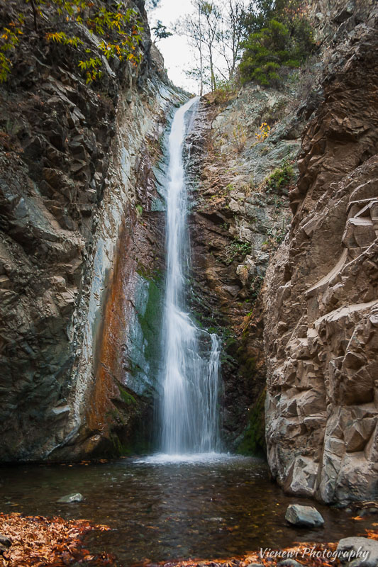
Chantara Waterfall (Καταρράκτης Χαντάρα)
- the loudest waterfall, and compared to the previous two, I would also say that it is the widest, most easily accessible and probably the most mesmerizing! And of course the least known by tourists 😊
 |
| Chantara Waterfall (April 2019) |
Where is Chantara Waterfall located?
Hantara Waterfall is situated in a national forest, 1.5 km north of the village of Fini (famous for its pottery). This is where the master who created Pitharie came from, traveling all around Cyprus.
It is located on the Dhiarizos River (δύο ρίζες) - meaning "Two Roots". In some sources, the same river is called "Diplos Potamos" meaning "Double River". Currently, it is often marked as "Trodotissa" on many maps.
The water falls in several streams from a height of 8 meters, over hard, volcanic gabbro rocks and forms a small body of water below. Then, under a small wooden bridge, it descends and flows down the river toward the village of Fini, through which it flows.
The rock of the waterfall is overgrown with velvety moss and it creates a really impressive view. This waterfall looks the most beautiful in spring - when the moss is still lush green; and in fall - when the whole area is in the colors of autumn and dry leaves float on the surface of the water.
The name of the Hantara Waterfall - originates from the word "antara/andara" which locals use as a "running water noise".
On the right side of the waterfall, you can notice stone steps leading up to the top, above the waterfall. There are two more levels - a cascade of smaller waterfalls.
One could spend hours sitting here and marveling at this natural wonder!
Vegetation
In the immediate vicinity of the waterfall and the riverbed, plane trees (Platanus orientalis) dominate - covered with ivy, alders (Alnus orientalis) along with other water plants. The whole area is mainly pine forests (Pinus brutia), golden oak (Quercus alnifolia), strawberry tree (Arbutus andrachne) and many other shrubs - holy bramble (Rubus sanctus), myrtle (myrtus communis), sumach (Rhus coriaria) and wild herbs (mainly cistus, lavender and sage).
Near the waterfall, there are fragments of an old water mill, which operated until the beginning of the 20th century.
While preparing this post, I looked at the map and noticed that the same river flows next to Trodotissa, where we used to rock climb.
How to reach Chantara Waterfall?
As always, I would recommend getting to the waterfall on foot 😉 along the trail where you can observe the surrounding, rich vegetation, take advantage of the therapeutic benefits of nature and, by the way, notice elements that you would surely miss if you were traveling by car - such as the bas-relief of Christ on a rock.
1. Hiking trail from Fini (Foini/Phini - 920 meters above sea level) - 1.5 km, mainly on a paved road.
The trail from Fini to Chantara starts at an elevation of 930 meters and ends at the waterfall at an altitude of approximately 1035 meters.
2. Trail from Trodotissa to Fini - paved road.
The trail starts 400 meters from the Trodotissa Monastery (1330 meters above sea level). After about 3.5 km of descent, you will reach the Hantara Waterfall. The entire trail is 4.5km long.
It is highly recommended to use trekking poles for this descent to ease the strain on your knees.
3. Trail from the village of Pano Platres to Chantara - 5.5km - asphalt and paved road.
4. You can also drive almost to the waterfall itself.
I've been here a few times, but I think I liked it the most when we reached it after a long trek trail from Trodotissa.
It's great to sit by this waterfall, relax and rejuvenate. Gaze at the falling water or streams flowing down the rock covered in moss. Listen to the sound of falling water and the singing of nearby birds. To relax...
When I first came to this waterfall, I liked it so much that I got dreamy and said that I would like to have a house near such a waterfall that it would be great to waking up to the sound of a flowing stream outside my window. I admired the house built nearby and envied them a bit for the landscapes. 😋
Chantara Falls coordinates: 34°54'17.8"N 32°50'26.3"E
Otherwise written name: Hantara, Xantara, Khantara, Chandara, Handara
Ending
All these waterfalls are very charming and breathtaking. They may not be as big (you can see anywhere in other countries), but they are equally fascinating and in their vicinity, you can observe many endemic plants that you will not find anywhere else.
condensed version
The recommended time for a walk along the trails to the waterfalls is: from March to November.
If you are going on hiking trails, be sure to think about appropriate footwear. These routes are not suitable for high heels or flip-flops (which, unfortunately, can often be observed).
Take a look at the guide
"Cyprus Nature Trails" (pdf),
Department of Forests - Ministry of Agriculture. The trails are nicely shown on the maps. It is also worth using the abbreviated form - the leaflet of the Kaledonia Trail.
I'm curious, which route would you choose to reach the waterfall?
Which waterfall do you like the most?
Have you visited any of them already?
Do you know any other waterfalls in Cyprus? Maybe there's one I haven't heard of yet?!
Share your thoughts in the comments ☺
Sources
Cyprus Alive Καταρράκτης Χαντάρας
Limassol Tourism - Troodos Waterfalls
Ministry of Agriculture, Natural Resources and Environment, Nicosia 2013 Cyprus Nature Trails, Department of Forests
Ministry of Agriculture, Natural Resources and Environment, Vegetation and Flora of Cyprus (Chlorida ths Kyproy En)
Totalfish.ru The largest waterfall in Cyprus. Troodos Waterfalls
Information boards along the trails


0 comments: